
Hurricane Dorian: Sumter, Clarendon counties under tropical storm watch
Shelters opening in Clarendon County on Wednesday
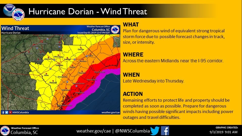
Sumter County is now under a tropical storm watch as winds between 20-30 miles per hour and gusts up to 45 mph are now expected within the next 48 hours.
According to the National Weather Service, Sumter is forecasted to get 1-3 inches of rain. The biggest threat currently is expected to be from wind Wednesday night and into Thursday.
The National Weather Service in Columbia said the area of the Midlands to the east of the Columbia area and near Interstate-95, which runs through Sumter County, have a greater risk than the central Midlands do.
The agency shows in a graphic on Twitter that the possibility of tropical storm force winds are at 40-50% in Orangeburg and Sumter, 54% in Florence, 30-40% in Barnwell and 30% in Columbia.
The threat of tropical storm force winds will extend inland. Those in the eastern Midlands (the areas east of the Columbia area and near I-95) have a greater risk than the central Midlands. Prepare for strong winds that begin late Wednesday. pic.twitter.com/4cjRxK7t2S
— NWS Columbia (@NWSColumbia) September 3, 2019
Red Cross shelters now open in South Carolina
The American Red Cross is preparing those in the path of Hurricane Dorian by coordinating with community partners and emergency responders as the now Category 2 storm tracks the southeast coast.
Evacuation centers across the coast opened this weekend as 60,000 people in Florida, Georgia and the Carolinas may need emergency shelter.
The Red Cross of South Carolina stocked up on supplies such as water and food to provide to those taking shelter.
There are currently 19 emergency shelters across the state located in Marion, Lake View, Walterboro, Little River, Ridgeland, Hemingway, Summerville, Dillon, Denmark, North Charleston, Galivants Ferry, Conway and Loris.
About 150 meals and snacks are provided to residents seeking shelter, as well.
Three shelters will open at 4 p.m. on Wednesday Sept. 4 in Clarendon County:
- Old Scott’s Branch High School Resource Center: 1154 Fourth St, Summerton
- Manning High School: 2155 Paxville Hwy. Manning
- East Clarendon High School: 1171 Pope St,, Turbeville
Take any medications and any other comfort items you may need with you. No animals will be accepted at these shelters.
Those who plan to stay in a Red Cross shelter must bring any needed prescription medications, extra clothing, pillows, blankets, hygiene supplies, other comfort items and important documents.
Other important items to bring may include any special items for children, such as diapers, formula and toys, or for family members who have unique needs.
All disaster assistance is free, and the Red Cross doesn’t require people to show any kind of identification to enter a shelter — just their name and pre-disaster address.
The Public Information Phone System is taking calls. Give us a call if you need help. We’re here 24/7. 1-866-246-0133 #Dorian #HurricaneDorian
— SCEMD (@SCEMD) September 2, 2019
Storm tide sensors installed to track Dorian in Carolinas
As forecasts show Hurricane Dorian slowly moving towards the U.S., potential flooding and erosion along the coasts of the Carolinas and Georgia is possible.
U.S. Geological Survey scientists installed 150 storm-tide sensors and about 22 other instruments along the North Carolina and South Carolina coasts to track the storm’s effect.
“A storm-tide sensor is a device that measures the storm surge that comes in during the storm,” USGS Hydrologist Tim Lanier said. “We’re going to be deploying about 70 here in South Carolina.”
On Monday and Tuesday, field crews from USGS South Atlantic Water Science Center started installing 70 storm-tide sensors in South Carolina and 90 in North Carolina.
Lanier said placing storm-tide sensors helps identify areas that are hard-hit by the storm surge, and it will help local officials during the recovery efforts after the storm.
Storm surge, coastal erosion and inland flooding are the most dangerous natural hazards made by hurricanes. All can lead to destroying homes, wiping out roads, bridges, water and sewer systems and alter landscapes.
“It’s a much safer way of monitoring the event as it’s actually happening,” Lanier said. “They can’t have personnel at these spots because it’s dangerous.”
While placing the sensor devices, crews in South Carolina were working in the eight counties that were placed under mandatory evacuation by Gov. Henry McMaster on Monday.
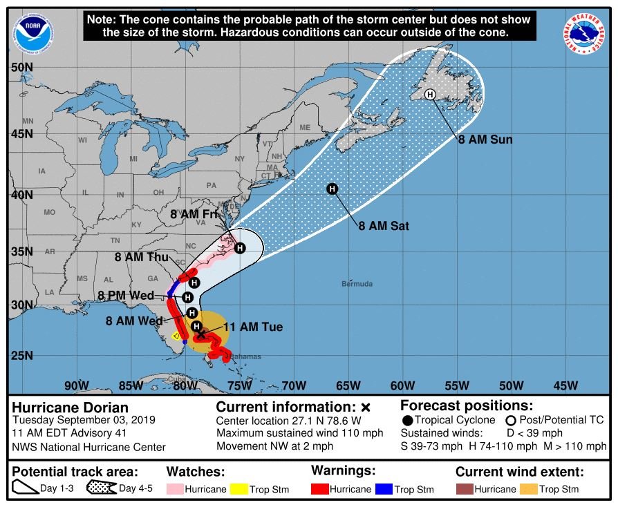
Hurricane Dorian is now a Category 2 storm slowly moving northwest toward the U.S. at 2 mph. It was previously a Category 5 storm with 185 mph sustained winds and 220 mph gusts on Sunday.
After stalling over the Bahamas on Monday, Bahamas officials said at least five people died and about 21 were injured and airlifted to the capital by the U.S. Coast Guard.
At 11 a.m. Tuesday, the Category 2 storm had 110 mph maximum sustained winds, according to the National Hurricane Center.
Florida and the Southeast Coast watch the storm miles off the Florida coast
Florida is currently out of the hurricane’s cone that predicts where the eye will track, but the state and the Southeast Coast is still expected to feel effects.
The storm is projected to continue moving north-northwest towards the coast of Georgia and the Carolinas and is expected to affect the states Wednesday into Thursday.
---
We will keep giving updates throughout the day, so stay tuned here.