
Preparing for impact: Hurricane Florence takes a more westward track as McMaster lifts some mandatory evacuations, closings
Florence, now a Category 3 hurricane, looking to cross through South Carolina
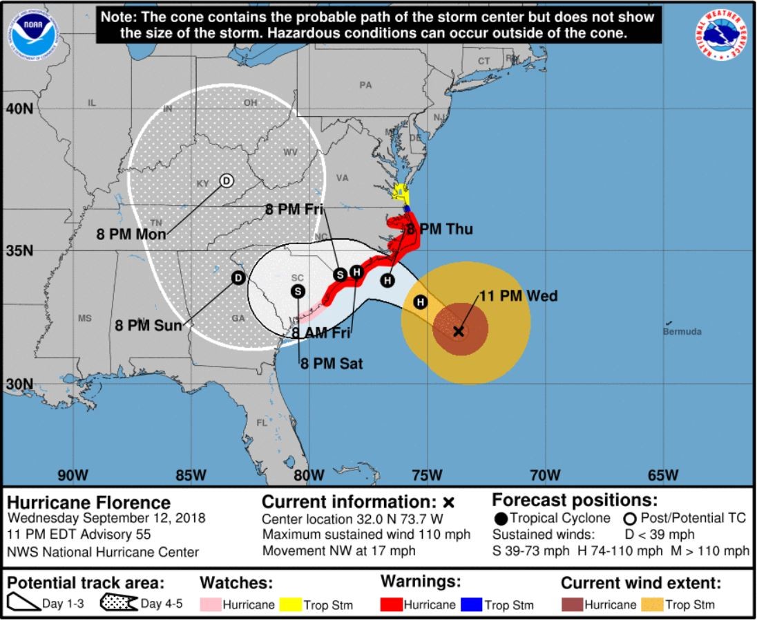
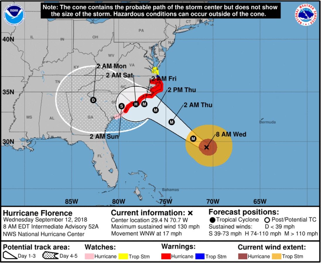
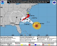

With slight variations in the forecast on the exact bullseye and arrival time, Hurricane Florence continues to head straight toward to Carolinas. Following is the latest information you'll need to know about what is coming and how to prepare in Sumter, Lee and Clarendon counties. 11 p.m. Florence has been downgraded to a Category 2 hurricane with maximum sustained winds of 110 miles per hour, but the breadth of the storm has grown. According to the National Hurricane Center’s 11 p.m. advisory, the storm, which had been as strong as a Category 4 with 140 mph winds earlier this week, was moving to the northwest at about 17 mph and is generally decreased in forward speed. “A turn to the west-northwest and west at an even slower forward speed is expected Thursday night and Friday, and a slow west-southwestward motion is forecast Friday night and Saturday,” the advisory said. “On the forecast track, the center of Florence will approach the coasts of North and South Carolina on Thursday, then move near or over the coast of southern North Carolina and eastern South Carolina in the hurricane warning area on Thursday night and Friday. A slow motion over eastern South Carolina is forecast Friday night and Saturday.” An Air Force Reserve Hurricane Hunter aircraft gave reports that indicate there will be little change in strength before the center reaches the coast with “weakening expected after the center moves inland.” Hurricane force winds now extend up to 80 miles from the center, and tropical storm-force winds now extend up to 195 miles from the center. 4 p.m. City of Sumter and Sumter County Government offices will be closed Thursday, Sept. 13 and Friday, Sept. 14, with an anticipated return to a normal schedule on Monday, Sept. 17 at 8:30 a.m, according to Joe Perry, spokesman for the county. City of Sumter trash, recycling and debris pickup is canceled for Friday but is expected to resume normal services on Monday. All city parks will also be closed starting Thursday until further notice, said Shelley Kile, communications and tourism director for the city. Perry said pets are not allowed at the shelter open at Mayewood Middle School, located at 4300 W. Brewington Road. 2 p.m. Florence’s peak winds have decreased slightly and is now a Category 3 hurricane, according to the 2 p.m. update from the National Hurricane Center, but the size of the wind field has increased as it creeps nearer to the coast of the Southeastern United States and the Carolinas. As of 2 p.m., reports from an Air Force Reserve reconnaissance aircraft indicated the hurricane was located about 470 miles east-southeast of Myrtle Beach with maximum sustained winds of 125 miles per hour. It is heading northwest at 16 mph. Watches and warnings have not changed. 1:30 p.m. City of Sumter Public Works has been concentrating heavily on storm drains for about the last week, said Al Harris, public works director and assistant manager of the city of Sumter. The Parks and Garden Department, which is part of public works, has been doing tree work as well, he said. For large storms, he said, all you can do is prepare and evaluate when it happens and quickly react afterward. Locally, the reaction depends on the amount of wind, he said. But if there are hurricane-force winds, Harris said it doesn't matter what preparations are done beforehand because that's a whole different ball game. Public works is definitely staying on top of things as best it can, he said. (Reporting by Adrienne Sarvis) 11 a.m. According to the 11 a.m. National Hurricane Center forecast, Hurricane Florence is continuing to shift southward through South Carolina after Air Force hurricane hunter aircraft found the Category 4 storm has changed little while moving toward the U.S. Southeast coast. As of 11 a.m., the storm was located about 520 miles east-southeast of Myrtle Beach with maximum sustained winds of 130 miles per hour. It is moving northwest at about 15 mph. The rest of the forecast remains the same from the 8 a.m. update. 10 a.m. Duke Energy announced $145,000 in grants to the American Red Cross to support response efforts to Hurricane Florence. The funds will support shelters, volunteer training and mobilization of volunteers. “The Red Cross has activated our volunteers across the Carolinas to prepare for this brutal storm,” said Barry Porter, regional executive for American Red Cross. “Duke Energy’s generous donation ahead of the storm helps the Red Cross mobilize support to vulnerable communities and prepare for an extended period of relief work. During the decades of Red Cross disaster response in the Carolinas, Duke Energy consistently steps up to enable the Red Cross to do even more.” 8 a.m., Sept. 12 Closures and preparations Public schools throughout Sumter, Lee, Clarendon and 23 other counties were closed on Tuesday and will remain closed until further notice, as ordered by Gov. Henry McMaster on Monday. He also ordered mandatory evacuations from the entire coast to begin Tuesday at noon, so inland school facilities and buses are available for shelters and transportation. McMaster lifted on Tuesday the mandatory evacuations in the southern-most parts of the state, including zones in Beaufort, Colleton and Jasper counties with the exception of Edisto Beach, according to the South Carolina Emergency Management Division. Mandatory evacuations remain in effect for all zones in Horry, Georgetown, Charleston, Berkeley and Dorchester counties. Private schools in the area are closing, too, and state government offices are also closed from the governor’s order, though he did on Tuesday lift the mandatory closures of schools and state offices in Aiken, Bamberg, Beaufort, Barnwell, Colleton, Hampton and Jasper counties. As of Tuesday afternoon, no decision had been made about the closure of Sumter city or county offices, according to Joe Perry, spokesman for the county. Representatives from the City of Sumter, Sumter County Government, Sumter Fire Department, Sumter Police Department, Sumter County Sheriff’s Office, Sumter County Emergency Medical Services and Sumter County Coroner’s Office met Tuesday afternoon to discuss the potential impact from Florence on the area. “Traffic is expected to increase in the area, and we urge motorists to be patient and mindful that people are evacuating the coast,” Perry said. As the entire state is preparing for Florence’s arrival, the Palmetto SC Region of the American Red Cross is also getting volunteers ready to open shelters and respond to any disaster as it may occur. Anyone who wants to volunteer at shelters should visit www.redcross.org/sc to start an application. After that, a member of the Red Cross will reach out, and a background check will be performed. “For days now, our dedicated volunteers have been working non-stop to prepare for Hurricane Florence,” said Louise Welch Williams, regional CEO. “If South Carolina residents are looking for volunteer opportunities, the Red Cross would love them to join our team.” The Red Cross says sending food and clothing does more harm than good because it takes time and money right now to sort and store the items, which diverts limited time and resources away from helping those most affected. Help people affected by disasters large and small by texting “FLORENCE” to 90999 to make a $10 donation.