
The latest: Sumter schools, government offices closed Thursday as Hurricane Michael heads into Georgia
Plus, other vital information you need to know

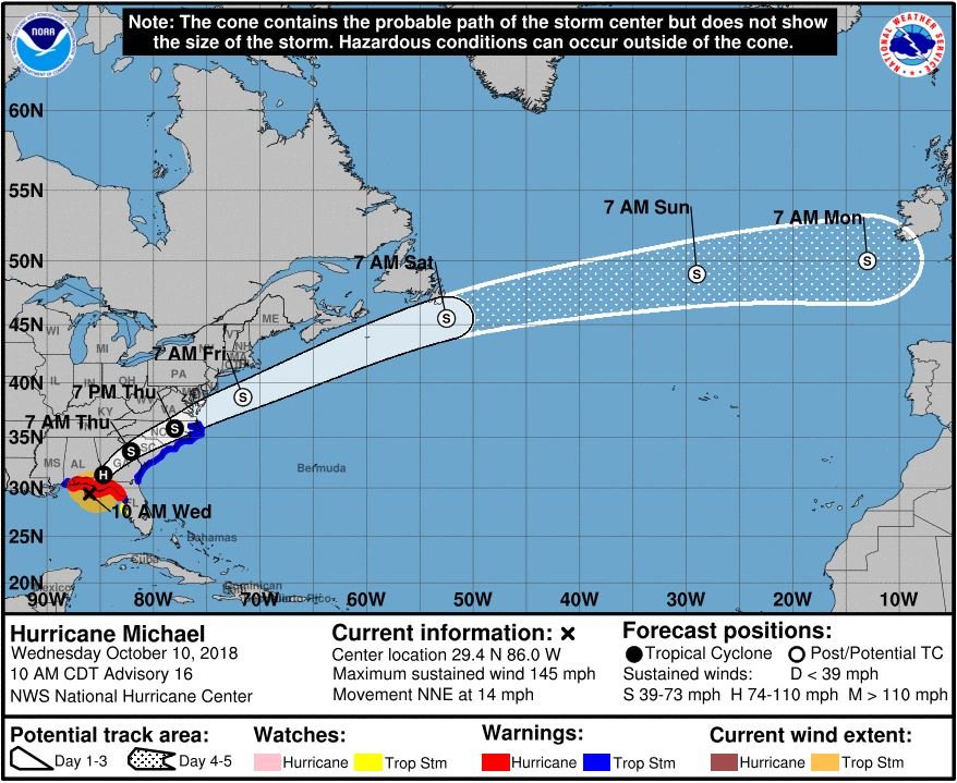


Hurricane Michael is a major hurricane sitting as a Category 4 with maximum sustained winds of 145 miles per hour, the most powerful storm on record to ever strike the stretch of the Florida Panhandle it is about to make landfall on. Stay tuned here for updates as it approaches the Sumter and South Carolina area and its possible effects, including closings and other vital information.
---
11 p.m.
Hurricane Michael, now a Category 1 storm with maximum sustained winds of 75 mph, is moving across south-central Georgia on its way to South Carolina.
According to the National Hurricane Center’s 11 p.m. Wednesday public advisory, the storm is quickening its face to near 20 mph, a “general motion” that “should continue tonight.”
It is expected to be a tropical storm by Thursday morning.
Hurricane-force winds were extending up to 30 miles from the center, and tropical storm-force winds were extending outward up to 160 miles from the center.
---
10 p.m.
NOAA Doppler weather radar is indicating the center of the now-Category 1 Hurricane Michael is moving into south-central Georgia.
According to the National Hurricane Center, a National Ocean Service water level station at Apalachicola is now indicating about 2 feet of inundation above ground level.
Michael is sustaining maximum winds of 80 mph as it continues to move swiftly northeast at 17 mph.
---
8:30 p.m.
The National Weather Service issued multiple tornado warnings in Georgia as Hurricane Michael pushed through the state, and local media report three of them may have touched down.
News media in Macon reported that by early evening Wednesday, tornadoes had touched down near Roberta, Perry and Fort Valley in Georgia's midstate region.
Crawford County officials said a possible tornado damaged five homes near Roberta. The county's emergency management director told news media it touched down on Highway 128 and knocked down power lines and trees. No injuries were reported.
Weather officials had warned that the massive storm, which came ashore Wednesday afternoon in Florida's Panhandle region, could spawn tornadoes as it moves northeast.
(From The Associated Press)
---
7:25 p.m.
Hurricane Michael has left extensive damage in Panama City, with broken and uprooted trees and power lines down nearly everywhere. Roofs were peeled off and homes split open by fallen trees. Twisted street signs lay on the ground. Residents emerged early Wednesday evening to assess damage when rains stopped, though skies were still overcast and windy.
A pine tree punched a hole in the roof of the apartment where 29-year-old Vance Beu was staying with his mother. The roar of the storm sounded like a jet engine as the wind accelerated, and their ears popped as pressure dropped.
Beu said, "It was terrifying, honestly. There was a lot of noise. We thought the windows were going to break at any time. We had the inside windows kind of barricaded in with mattresses. We did whatever we could to kind of hunker down."
(From The Associated Press)
---
7 p.m.
Authorities say a Florida Panhandle man was killed by a falling tree as Hurricane Michael tore through the state.
Gadsden County Sheriff's Office spokeswoman Anglie Hightower says they received a call around 6 p.m. Wednesday, saying a tree had crashed through the roof of the man's Greensboro home and trapped him. Emergency crews were heading to the home, but downed power lines and blocked roads were making the trip difficult.
Officials hadn't immediately confirmed the man's name.
(From The Associated Press)
---
4 p.m.
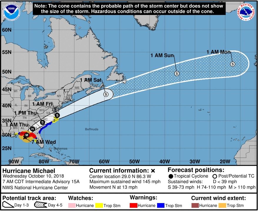
Michael has weakened to a Category 3 hurricane as it moves inland into southeastern Alabama and southwestern Georgia.
The storm is moving 16 mph with maximum sustained winds near 125 mph, according to the National Hurricane Center’s 4 p.m. public advisory.
As of the South Carolina Department of Transportation’s 4 p.m. update, there are still 58 closures in areas that remain affected by Hurricane Florence, including six storm-related closures on major routes in the northeastern corner of the state. SCDOT is continuing recovery operations in that area.
There are 1,786 maintenance employees working in preparation of Michael.
---
3 p.m.
Authorities say lifeguards had to save three children who were playing in the ocean at a South Carolina beach as Hurricane Michael approached.
Beaufort County Emergency Management Division Commander Neil Baxley said a 15-year-old and two 9-year-olds were on boogie boards off Hilton Head Island around 12:15 p.m. Wednesday when the waves quickly started to pull them from shore.
Baxley says rescuers were able to make it to the children and bring them to safety.
Baxley said at a news conference there is no reason to be in the ocean Wednesday.
Beaufort County is under a tropical storm warning as Michael makes landfall about 325 miles (520 kilometers) southwest in the Florida Panhandle.
(From The Associated Press)
---
1 p.m.
Hurricane Michael has intensified just before making landfall at Mexico Beach, Florida, according to the National Hurricane Center.
The storm is considered an “extremely dangerous” Category 4 hurricane on the Saffir-Simpson Hurricane Wind Scale with maximum sustained winds near 155 mph. It is moving north-northeast near 14 mph and is expected to begin to move faster as it turns northeast Wednesday afternoon or night, the agency said in its 1 p.m. public advisory.
“Michael should weaken as it crosses the southeastern United States. Michael is forecast to become a post-tropical cyclone on Friday, and strengthening is forecast as the system moves over the western Atlantic,” the advisory said.
---
12:25 p.m.
There is a social media post circulating about a curfew declared for Sumter County. The curfew is for Sumter County, Georgia, not South Carolina, according to the Sumter County Sheriff's Office.
---
Noon
The offices of the City of Sumter, South Carolina and Sumter County government will be closed Thursday, Oct. 11.
All City of Sumter residential and commercial sanitation services, including garbage, recycling and debris, are postponed. Thursday customer routes will resume a regular schedule next week.
All city parks will be closed Thursday.
---
11:20 a.m.
Shaw Air Force Base has now entered a Hurricane Condition 2 (HURCON 2), which means destructive winds are possible within 24 hours, and has evacuated its F-16 CM Fighting Falcon aircraft.
The base will maintain normal operating status through Wednesday, Oct. 10.
Beginning Thursday, Oct. 11, only mission-essential personnel should report for duty. Civilian personnel are authorized administrative leave beginning at 2 p.m. on Wednesday. For further reporting instructions, contact your supervisor.
---
11:15 a.m.
South Carolina remains in a state of emergency due to continued flooding from Hurricane Florence and potential impacts from Hurricane Michael, Gov. Henry McMaster announced Wednesday.
McMaster signed an executive order to extend the state of emergency due to Michael’s potential impacts compounding on the state still recovering from Florence, including where flood waters still remain in portions of Horry County and Marion County and on 49 roads and 24 bridges that are still closed, according to the order.
“While we will not see the full force of Hurricane Michael the way Florida will, we could see gusty winds, rain, flash flooding and even tornadoes,” S.C. Emergency Management Director Kim Stenson said. “Over the next day, it will be vital for everyone to be prepared to act if told to do so by your local public safety officials.”
Residents should take the following safety precautions:
* Have a plan for where you will go if conditions become too unsafe to remain in your home.
* Create your emergency plan by visiting scemd.org or downloading the SC Emergency Manager mobile app: http://onelink.to/dn92rx.
* Have an emergency kit with items such as: bottled water, non-perishable food and flashlights with extra batteries. Refer to the preparedness checklists in the2018 S.C. Hurricane Guide.
* Include items for your pets in your emergency kit.
* Prepare your home or business by securing any items you have in your yard by taking them indoors.
* The probability of power outages is increased due to tropical storm force winds.
* Make sure you have some cash in case of power outages
* Frequently monitor weather conditions and be aware that tornadoes are likely spawned during a hurricane or tropical storm.
* If you are under a tornado warning, seek shelter immediately. Take shelter immediately in a house or small building. If there is no basement, go to an interior room on the lowest level. Get under a sturdy table and cover your head. Stay there until the danger has passed.
* In a vehicle, trailer or mobile home, get out immediately and go to a more substantial structure. If there is no shelter nearby, lie flat in the nearest ditch and cover your head. Do not attempt to outdrive a tornado.
* Keep all of your important papers in a watertight bag.
* Check with your pharmacy to make sure all important medications are filled.
The path is projected to impact most of the state, with many counties under a tropical storm warning and flash flood watch. Residents should continue to monitor local media and official, verified social media accounts from public safety agencies for the latest information.
---
11:05 a.m.
Emergency shelters will begin opening as Hurricane Michael nears, according to the Palmetto S.C. Region of the American Red Cross.
Two shelters will open Wednesday at the request of local emergency management partners, according to Cuthbert Langley, spokesman for the Palmetto S.C. Region, and the agency is expecting more to open today.
The two shelters with planned Wednesday openings are:
* North Charleston, 3765 Leeds Ave – opening at noon
* First Baptist Church of Barnwell, 161 Allen St., Barnwell – opening at 2 p.m.
Cots will be available, but people are asked to bring important medications, pillows, additional blankets, hygiene items and other necessities or comfort items, especially for children or anyone with special needs.
---
10 a.m.
All Sumter School District schools and offices will be closed Thursday, Oct. 11 due to the threat of inclement weather from Hurricane Michael. The closure is “out of an abundance of caution,” school officials said. Schools will reopen Friday unless announced otherwise. Wednesday is a full day for student attendance.
---
7 a.m.
State/FEMA Disaster Recovery Centers addressing residents’ needs after Hurricane Florence will close temporarily due to poor weather conditions.
DRC’s located in Chesterfield, Dillon, Georgetown, Horry, Marion and Marlboro counties will close at 7 p.m. Wednesday, Oct. 10 and plan to re-open on Friday with new hours of 9 a.m. to 6 p.m. Monday through Saturday. The centers will be closed on Sunday.
Applicants can still check their eligibility and register for federal, state and voluntary agency disaster assistance from Florence by:
* Visiting https://www.disasterassistance.gov
* Calling 800-621-3362
* Using the FEMA app available for Apple and Android mobile devices at fema.gov/mobile-app.
---
5:21 a.m., Wednesday, Oct. 10
Sumter, Lee and Clarendon counties are under a tropical storm warning, meaning tropical storm-force winds are expected somewhere within this area within the next 36 hours, according to the National Weather Service.
According to the latest local forecast, 20- to 30-mph winds with 40-mph gusts are expected, and there is a potential for winds of 58 to 73 mph.
Peak rainfall amounts are forecasted to be 3 to 6 inches, and there is a “somewhat favorable” situation for tornadoes starting Wednesday night.
Sumter, Lee and Clarendon counties are also under a flash flood watch from 8 p.m. Wednesday through 11 p.m. Thursday.