
Updated: NWS in Columbia warns of potential severe storms through Tuesday, tornado watch issued until 6 p.m. for Sumter, Clarendon, Lee
12:32 p.m.
A tornado watch has been issued by the National Weather Service Columbia office for 18 counties in central South Carolina, including Sumter, Clarendon and Lee, until 6 p.m. Tuesday, Jan. 9.
According to the NWS, "Tornadoes are possible in and near the watch area. Review and discuss your emergency plans and check supplies and your safe room. Be ready to act quickly if a warning is issued or you suspect a tornado is approaching. Acting early helps to save lives! Watches are issued by the Storm Prediction Center for counties where tornadoes may occur. The watch area is typically large, covering numerous counties or even states."
Know what to do during a tornado warning
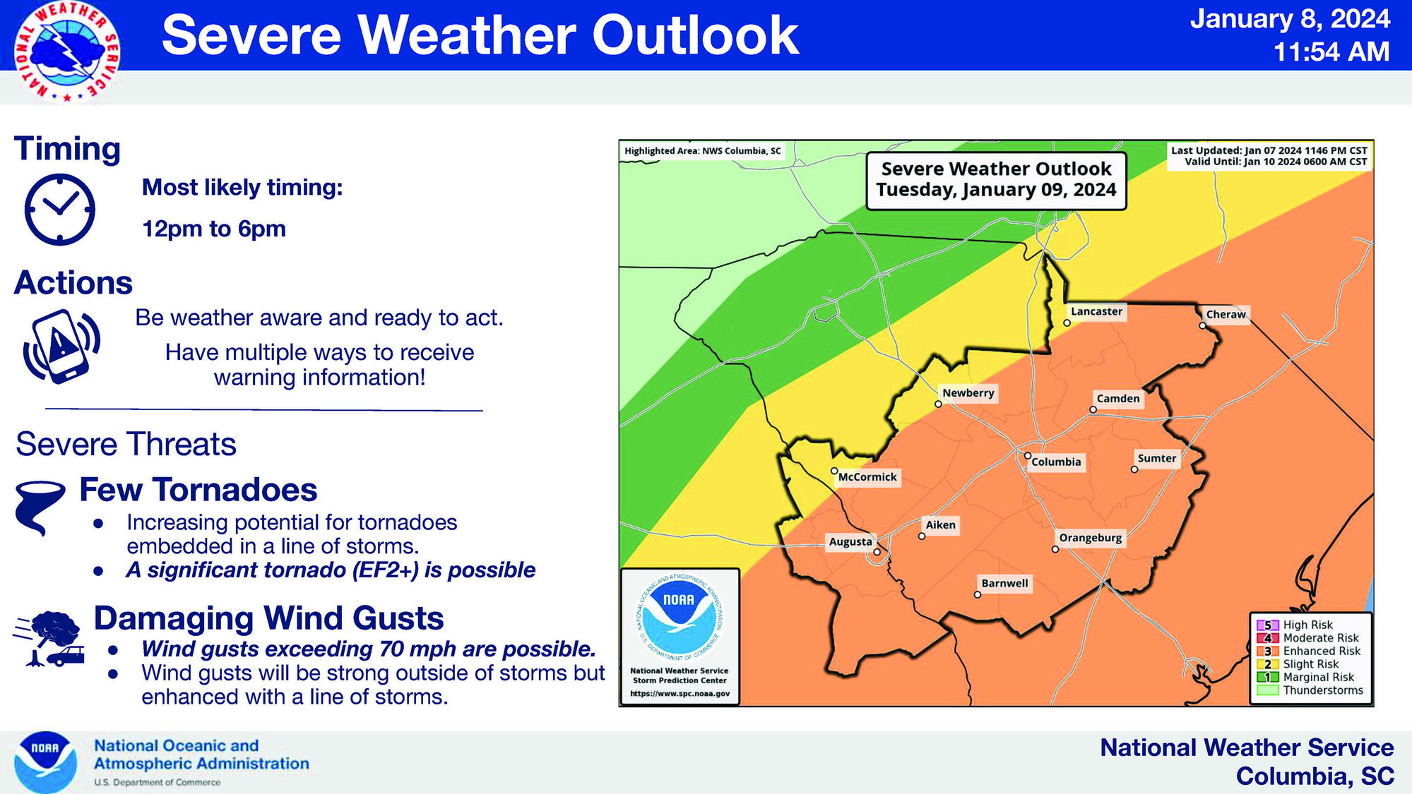
Update as of 11:54 a.m. from the National Weather Service:
"The issuance of a tornado watch is likely 80% within the next two hours for most of, if not all of, the forecasted area. In addition to the potential for strong, damaging winds and isolated tornadoes within thunderstorms, the NWS has received numerous reports of non-thunderstorm wind damage ahead of the line. The highest gust so far at the Columbia Metropolitan Airport is 38 miles per hour. "
While students prepared on Monday for their e-learning day of school today because of forecasted inclement weather, the National Weather Service, based in Columbia, had a few key messages for the public.
On Monday, Jan. 8, the NWS held an informational briefing with its staff. The Sumter Item was emailed the presentation to allow the public to get prepared for the weather.
The NWS is calling for severe weather Tuesday morning, including windy conditions outside of thunderstorms, for the central South Carolina and central Savannah River area of Georgia. The tri-counties, Sumter, Clarendon and Lee, fall into these categories.
NWS said winds will increase on Tuesday morning with gusts exceeding 40 miles per hour by late morning. A line of storms will move into the area Tuesday afternoon with the potential for significant severe weather, gusts of wind greater than 70 miles per hour and possible significant tornadoes of EF2 scale, which means with winds from 111 to 136 miles per hour.
Flash flooding risk is low, but river flooding is expected by the end of the week. The NWS expects one to two inches of rain to fall across the area.
Main points to know from The National Weather Service
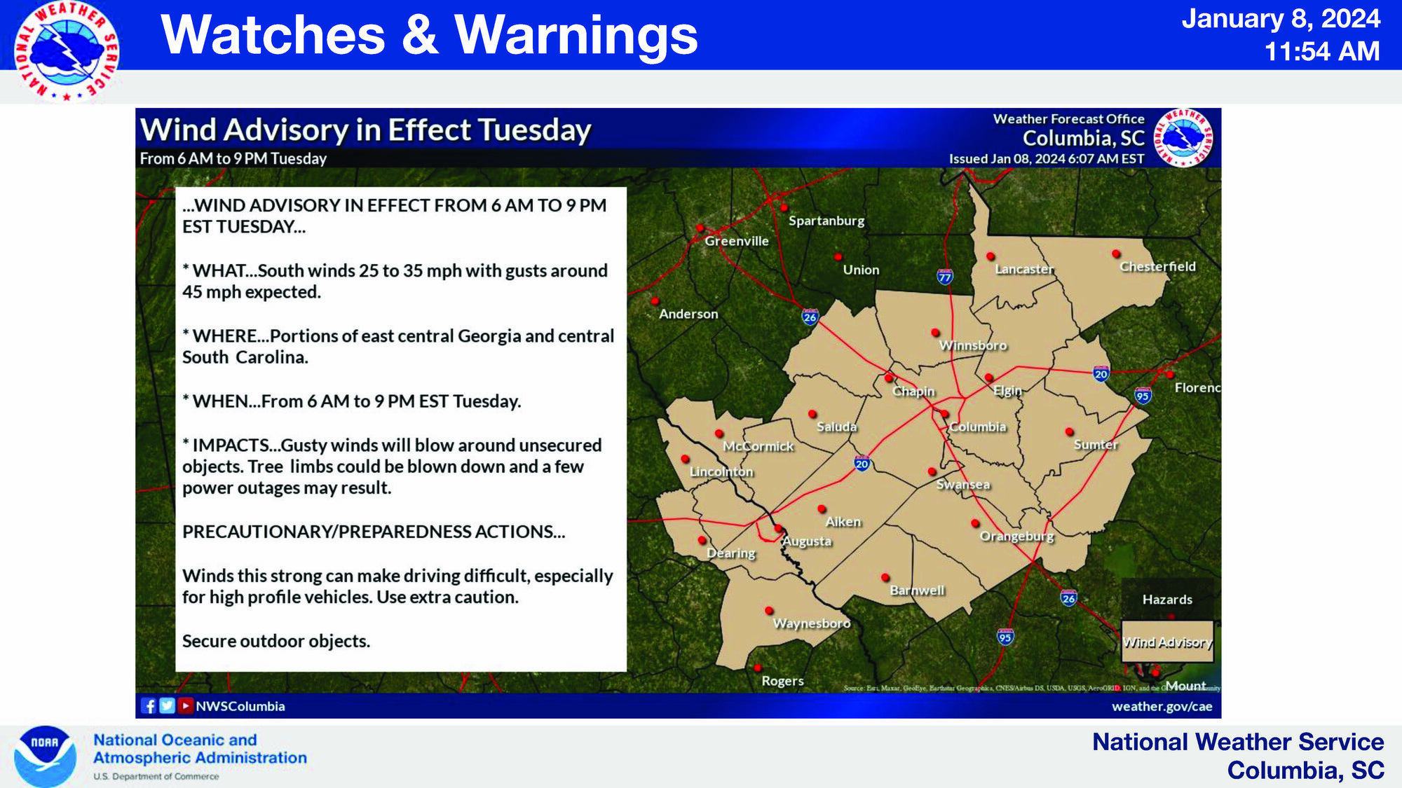
Strong, gusty winds outside of storms may lead to tree damage and blow around unsecured objects. A line of storms may cause considerable and widespread tree and power line damage. Between noon and 3 p.m. on Tuesday, expect more significant strong wind gusts.
Winds this strong can make driving difficult, especially for high-profile vehicles, according to the NWS.
Embedded tornadoes in a line of storms may lead to significant tree damage and structural damage. The NWS said a significant tornado (EF2) is possible. Between noon and 3 p.m., tornadoes have the most elevated potential in the area.
There will be limited flash-flood risk to urban and poor drainage areas. Flash flooding is possible Tuesday afternoon, and river flooding could begin Wednesday.
The NWS asks the public to be weather aware and ready to act while having multiple ways to receive warning and weather information.
Weather on Wednesday
The NWS projected the weather for Wednesday to be mostly sunny with highs around 50 degrees, breezy in the morning but with winds diminishing into the afternoon.
Visit www.weather.gov/cae or keep up with the National Weather Service Columbia South Carolina Facebook page for more information.