
Hurricane Dorian: Updates affecting Sumter, Clarendon, Lee counties for Wednesday, Sept. 4
Shelter opens in Sumter County
The former Mayewood Middle School at 4300 East Brewington Road is now opened in Sumter County as an emergency shelter.
The American Red Cross and the S.C. Department of Social Services are in charge of the shelter, and pets are not allowed.
--- (6 p.m.)
Dorian strengthens some as it heads north
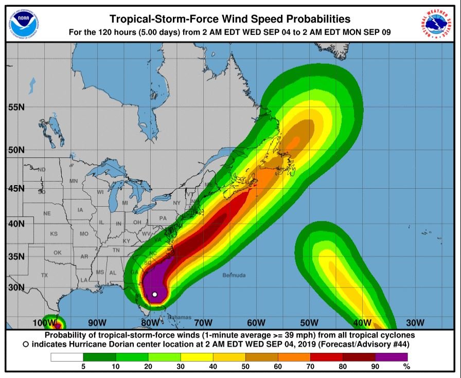
Hurricane Dorian strengthened a little as of The National Hurricane Center's 5 p.m. update. The eye is now of the coast of southeastern Georgia.
Sumter County peaked forecast winds are 25-35 mph for Thursday.
Dorian is located 150 miles south of Charleston with maximum sustained winds of 110 mph.
--- (5:10 p.m.)
Storm surge a concern along South Carolina coast
Officials in South Carolina county are warning about the potential for life-threatening flooding from Hurricane Dorian.
A statement from Georgetown County says anyone who lives near the waterfront in the coastal town of Georgetown should evacuate.
The city of about 8,900 people is located on the coast north of Charleston. It's situated along a bay and two rivers, the Great Pee Dee and the Sampit.
The county's statement says the National Weather Service contacted officials there to warn about the combination of storm surge and high tide at Georgetown on Thursday afternoon.
Rising seas caused by the storm could add as much as 6 feet to normal high tide levels. The county says anyone who doesn't leave may be putting themselves at risk.
--- The Associated Press (4:10 p.m.)
Sumter city, county government offices closing tomorrow
The offices of the City of Sumter and Sumter County Government will be closed on Thursday, Sept. 5, as Hurricane Dorian approaches the state.
Sumter County’s Emergency Operations Center will activate today at 6 p.m., according to a joint news release from the city and county.
Emergency shelter information will be announced later today.
For City of Sumter customers, residential and commercial garbage service and recycling for Thursday pick-up will be delayed until Saturday, Sept. 7. Yard debris pick-up will be delayed until your normal schedule resumes.
Sumter County Recreation & Parks will hold practice Wednesday, Sept. 4 with Thursday practice canceled. All City of Sumter parks will be closed on Thursday, as well.
City of Sumter and Sumter County Government are planning on resuming normal business hours on Friday, Sept. 6.
--- (4 p.m.)
Hundreds of thousands could lose power in Southeast
Utilities say Hurricane Dorian could leave hundreds of thousands without electricity in the southeastern United States as it moves up the Atlantic Coast.
Duke Energy says the slow-moving storm could cause more than 700,000 power outages in eastern regions of North Carolina and South Carolina based on current predictions.
The utility says some outages could last for several days, and problems are expected as far as 100 miles (161 kilometers) inland.
Georgia Power says about 2,800 homes and businesses are without power in coastal areas of Georgia and several thousand utility customers are in the dark in northeast Florida.
It isn't just electricity that's being affected. Brunswick County in coastal North Carolina is shutting off water and sewer service in advance of Dorian.
--- The Associated Press (3:40 p.m.)
Midlands will see impact from Dorian
The eye of Hurricane Dorian is now east of Jacksonville, Florida, with tropical storm warnings remaining in Sumter, Lee, Clarendon, Calhoun, Bamberg and Orangeburg counties.
The National Weather Service in Columbia has “high confidence we will see impacts from Dorian” in the Midlands, but exact details remain uncertain depending on the eventual strength and track of the system.
Residents across the Eastern Midlands “should be prepared” for inland tropical-storm-strength impacts such as:
- Heavy rain (flash flooding and river flooding)
- Strong winds (downed trees and power outages)
- Isolated tornadoes
The overall timing for impact to the Midlands is expected to be late Wednesday night through Friday morning.
--- (2 p.m.)
Shelter opening in Lee County
The American Red Cross will open an emergency shelter at Lee Central High School, 1800 Wisacky Hwy., Bishopville, at 6 p.m. on Wednesday.
Bring your own bedding, medicines, supplies and activities for children and snacks. The shelter will only provide basic necessities such as a cot to sleep on and military-style MREs for food.
--- (1:40 p.m.)
Dorian begins impact on Charleston
Rain from the outermost bands of Hurricane Dorian have been pelting downtown Charleston, South Carolina, where shops normally bustling with tourists are boarded up along King Street. The historic city sits on a peninsula that already floods at high tides, and the city is expecting trouble as Dorian's storm surge tops a 10 foot high tide on Thursday.
Hundreds of people in low-lying areas are evacuating to shelters ahead of the storm, supported by Red Cross volunteers.
U.S. Army veteran Mark Russell says he went to a shelter early to avoid the rush. He doesn't want to experience what he lived through during Hurricane Hugo, which slammed into South Carolina's coast in 1989, killing dozens of people and causing $6 billion in damage.
--- The Associated Press (1:10 p.m.)
Lane reversals delayed on I-26
Gov. Henry McMaster has delayed the breakdown of lane reversals on I-26 between Charleston and Columbia because there continues to be a steady evacuation flow on both sides.
Mororists can continue to use the eastbound lanes at this time, according to a Tweet from 45 minutes ago, until about 2 p.m.
--- (1:25 p.m.)
First North Carolina death from Dorian reported
North Carolina emergency officials are reporting the first death in the state related to Hurricane Dorian .
Gov. Roy Cooper said Wednesday that an 85-year-old man from Columbus County died from injuries when he fell off a ladder as he was trying to prepare his home for the approaching storm. The state emergency operations center didn't have the man's name, but a spokesman said he died Monday at a hospital in nearby Fayetteville.
Cooper warned the public at a news conference about the threat of flash flooding, storm surge and more than a foot of rainfall as Dorian arrives Thursday along the southeastern coast. The governor already has ordered evacuations on the state's fragile barrier islands.
At least seven deaths have been reported in the Bahamas from Dorian, with the full scope of the disaster still unknown.
--- The Associated Press (noon)
Sumter School District closed on Thursday
Sumter School District announced all schools and offices will be closed on Thursday, and all after-school programs, including athletics, are canceled for Wednesday.
The district is planning to resume normal operations on Friday.
Lee County School District also announced the same plan.
--- (10:55 a.m.)
Coastal prison will not evacuate
South Carolina Department of Correction officials have decided not to evacuate a coastal prison that houses about 950 inmates, although Hurricane Dorian is projected to head toward the area by midweek.
The department tweeted Monday that staff and inmates at the Ridgeland Correctional Institution in the Jasper County evacuation zone will remain at the prison during the storm. Inmates with extra medical needs were evacuated.
The department says Ridgeland has enough supplies to last several weeks. The department says they believe Ridgeland is the safest place for staff and inmates. It says Ridgeland opened in 1995 and has never been evacuated.
The State newspaper reported an inmate previously died at Ridgeland in 2016 during Hurricane Matthew. Then-Gov. Nikki Haley said the death was "seemingly unrelated."
--- The Associated Press (10:25 a.m.)
Lane reversals to stop on I-26 Wednesday at noon
Anyone still trying to leave the coast has just a few hours to use the reversed lanes on Interstate-26 to evacuate. According to the South Carolina Emergency Management Division, “now is the time to leave.”
Law enforcement will begin breaking down the lane reversals on I-26 between Charleston and Columbia Wednesday at noon.
--- Kayla Robins (10:45 a.m.)
Storm moving parallel to Florida coast
Hurricane Dorian is now moving parallel to the northeastern coast of Florida.
As of the 10 a.m. National Hurricane Center update, the storm is about 90 miles east-northeast of Daytona Beach, Florida, packing maximum sustained winds of 105 mph and moving north-northwest at 8 mph.
Hurricane-force winds extend outward up to 60 miles from the center, and tropical storm-force winds extend outward up to 175 miles from the center of the storm.
--- Kayla Robins (10:30 a.m.)
Dorian expected to reach area tonight
As Hurricane Dorian continues to move up the East Coast, South Carolina expects the storm to reach its coast late tonight through the day Thursday.
Hurricane Dorian, a Category 2 storm, had sustained winds of 105 miles per hour moving north-northwest at 8 mph, with its core 95 miles off Florida’s coastline as of 8 a.m. Wednesday, according to the National Hurricane Center.
The storm battered the Bahamas as a Category 5 storm on Sunday, and seven people have been confirmed dead on the Bahamas' Abaco Islands as officials expect the death toll to rise.
Residents in Florida, Georgia and the Carolinas were warned to evacuate earlier this week.
Tropical storm warnings are in effect in several South Carolina counties in the Midlands, including Sumter, Clarendon and Lee. Along the coast, all counties are under a Hurricane warning.
A tropical storm warning means tropical storm conditions are expected within 36 hours. A tropical storm watch means tropical storm conditions are possible within 48 hours.
A hurricane warning means hurricane conditions are expected. A hurricane watch means hurricane conditions are possible.
Potential wind gusts for the Midlands could be 30-50 mph with 2-4 inches of rain fall.
South Carolina is projected to get a storm surge of 4-7 feet with 6-10 inches of rainfall near the coast. Potential wind gusts could be more than 60 mph.
The National Hurricane Center said Dorian’s core will move close to the east coasts of Florida and Georgia through tonight. The core is forecast to move near or possibly over the coast of the Carolinas Thursday into Friday morning.
Though the storm is weakening, it remains powerful and dangerous.
--- Shelbie Goulding (9:30 a.m.)
Continue to follow this feed, as it will be updated throughout the day as more informaiton becomes available.