
Northeastern Florida under flood threats from storms that have devastated coastal communities
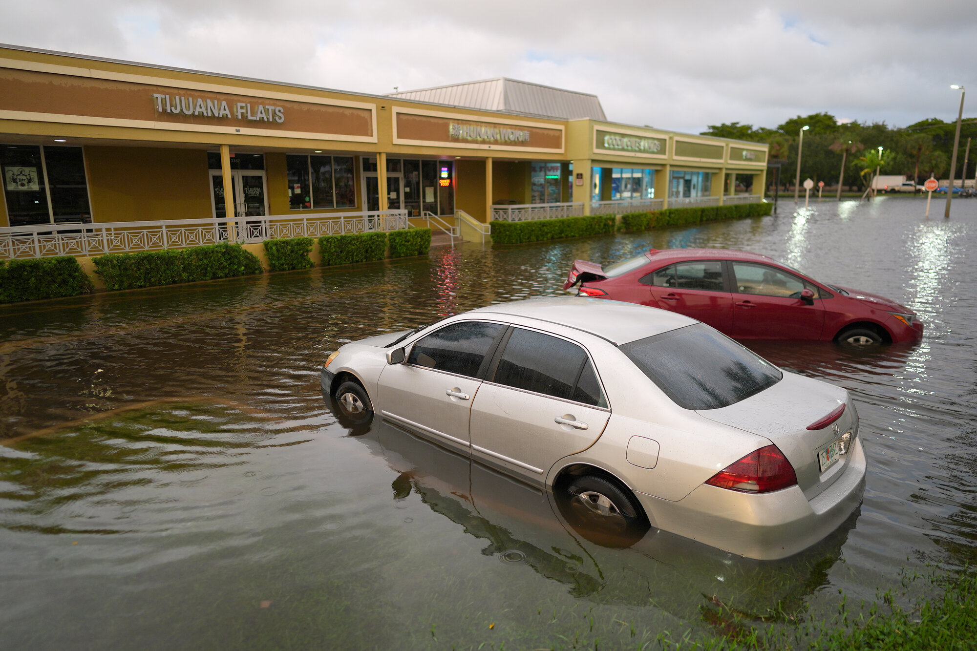
Heavy rains that left large swaths of Florida's Atlantic coast under water and led to dozens of rescues moved farther north on Friday as forecasters warned flooding threats could stretch into next week when a major river is expected to crest well above record levels.
The National Weather Service posted flood warnings and watches stretching around 200 miles from just south of Melbourne to the Jacksonville area. Additional rainfall of 2 to 6 inches was expected through Saturday, while some areas could see an extra 8 to 10 inches.
"Severe, widespread flash flooding is expected," the weather service said in a Friday morning forecast. "In addition, areas that normally do not experience flash flooding will flood. Furthermore, lives and property (are) in great danger."
The St. Johns River, Florida's longest, rose above a record level Thursday near Cocoa that was set in 1953. The river is forecast to stay at least 2 feet above flood stage through early next week, the weather service said.
Also Friday, a nontropical low-pressure system was expected to form and could become a subtropical or tropical storm along the southeastern U.S. coast, the National Hurricane Center in Miami said. The southeast and mid-Atlantic coasts should expect strong winds, dangerous surf and coastal flooding into early next week ahead of the Thanksgiving holiday.
Parts of Florida's east coast have been deluged with rainfall totaling more than 17 inches in some spots since Tuesday, according to preliminary totals by the weather service. That's in addition to heavy rains that fell earlier this month. Several places have already seen their wettest November on record.
The storms shifted north to the Space Coast on Thursday, sending rivers over their banks and prompting water rescues of people and horses during what is supposed to be Florida's dry season that runs from October to May.
"Never seen such a thing like this in Florida," said Jazmin Foster, whose Melbourne home was inundated with water for the second time in two weeks.
In Brevard County on Thursday, people with trailers braved knee-deep water to rescue dozens of horses and other animals at the Blue Lake Equestrian Center, an animal hospice and boarding facility in Cocoa. The animals were taken to a dry pasture elsewhere.
First responders conducted nearly 100 high-water rescues across the county, and those numbers continued to climb, Sheriff Wayne Ivey said. The city of Palm Bay conducted mandatory evacuations for some residents of a mobile home community. Shelters were opened for residents forced from their homes.
Nearly 200 Florida National Guard personnel with 50 high-water vehicles have been deployed to help up and down the coast, the Division of Emergency Management said. Other responding agencies included about 235 officers with the Florida Fish and Wildlife Conservation Commission.
This week's storms have been fueled by persistent high pressure over Virginia and a low-pressure system and an associated stationary front in the Gulf, which together have pushed a steady onshore flow across the Florida Peninsula. They're an offshoot of El Niño, the natural warming of the Pacific near the equator that warps weather patterns worldwide.
Forecasters said El Niño conditions are expected to persist through the spring, meaning the soggy extreme weather in Florida and California will likely continue through the winter.
"That's what the forecast models are saying," said Yale Climate Connections meteorologist Jeff Masters. "Winter hasn't even come yet - we're still in November. And things are likely to get even more active. And with record-warm ocean temperatures both off the coast of California and off the coast of Florida, we're going to be seeing some very heavy downpours."
In July, United Nations officials warned that El Niño would add fuel to the world's accelerating climate crisis, powered by the burning of coal, oil and natural gas.
Longtime Pompano Beach resident Ken Evans said he has seen heavier rain and flooding worsen, especially over the past five years.
On Tuesday night, he was caught in his SUV on Interstate 95 north of Miami during a heavy downpour with hail that left many roads under water.
"This is absolutely a whole new cycle that's going on and a cycle that we should be very concerned about," Evans said.
The California coast, from the Los Angeles to San Francisco areas, was also swamped with flooding in many areas this week, leaving neighborhoods under water and forcing some drivers to abandon stalled vehicles in floodwaters. A long stretch of the coastal Highway 1 was closed south of the Monterey Peninsula because of rock and mud slides.
This year's El Niño
El Niño is sizzling Pacific Ocean waters, leaking moisture into the air that can fuel passing storms. Such El Niño events can happen irregularly every couple of years, but scientists say the latest iteration is particularly extreme - and it's just getting started, with impacts expected for several more months.
"We've had super El Niños in the past, but this is a super duper El Niño," said meteorologist Jeff Masters of Yale Climate Connections.
The phenomenon is changing weather patterns around the world: regions including Peru and Ecuador are also seeing record-breaking flooding, Swain said. Parts of Southeast Asia, like Indonesia, are drier than usual.
Flash floods earlier this month prompted evacuations across northern New Mexico and central Arizona, and a Colorado ski town braced for its main river to rise to catastrophic levels.
The El Niño event is expected to peak in December, when it can more strongly harness certain air currents called jet streams to produce more extreme storms across the western U.S. After that, experts say its onslaught could continue for months.
"The dice are certainly loaded for more heavy storms this winter and spring," said Park Williams with UC San Diego's Scripps Institution of Oceanography in an email.
The impacts of an El Niño aren't wholly bad, meteorologist Randy Cerveny with Arizona State University, said: It can bring rainfall and moisture to drier areas like the Southwest and fill up reservoirs. At the same time, storms and floods can pose a danger to people and property.
To stay safe, experts recommended watching the forecast, planning ahead and heeding evacuation warnings from local authorities.
"We're not at the peak of the heating in the Pacific Ocean. So yes, we will see more of these particular events," Cerveny said.