
Tropical Storm Bertha poses flash flooding threat to Sumter, Midlands Wednesday
(Our coverage of inclement weather and immediate public safety matters is free to the public. It’s the right thing to do as a public service to our community. If you find this article helpful or informative and want to support our continued coverage, please subscribe or support us with a tax-deductible donation.)
---
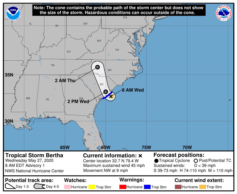
An onslaught of rain will continue, but it just so happens today’s rain will stem from a tropical storm that formed Wednesday morning off the South Carolina coast.
The second named storm of the season, which has not even officially started, is expected to bring heavy rainfall across portions of eastern and central South Carolina, the Midlands and then portions of North Carolina and Virginia by Thursday, according to the National Weather Service. It made landfall east of Charleston by 9:30 a.m. and showed maximum sustained winds near 50 miles per hour before landfall.
It is expected to dissipate into a depression as it moved inland.
Bertha’s main threat is expected to be flash flooding as it tracks northward across the central Carolinas across ground that is already saturated from recent rainfall. A flash flood watch was issued Wednesday morning for Sumter and is expected to be in effect through 10 p.m.
The federal weather agency is forecasting for Sumter periods of heavy rainfall later Wednesday morning into the afternoon that may lead to brief flooding. Isolated strong to severe thunderstorms will also become possible late Wednesday morning into the afternoon.
The flash flood watch also includes Lee and Clarendon counties.
After Wednesday, the threat in the Midlands is expected to be over.
Once Bertha leaves the area, the rain is not expected to slow.
The forecast for Sumter shows continued rain and thunderstorms amid high temperatures through the weekend.
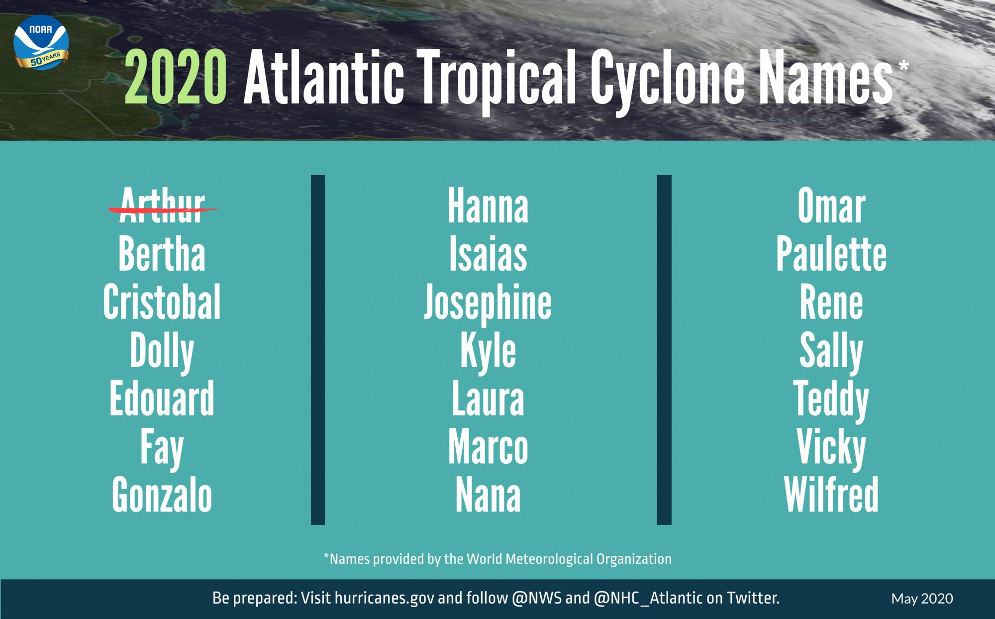
Bertha is the second named storm this Atlantic hurricane season already, which officially starts June 1. This marks the sixth straight year that a named storm has developed before the season starts.
Earlier this month, Tropical Storm Arthur brought rain to North Carolina before moving out to sea.
According to The Associated Press, the last time there were two named storms before June was in 2016, according to Phil Klotzbach, a research scientist with Colorado State University's atmospheric science department. It also happened in 1887, 1908, 1951 and 2012, he said.
"Most of these early-season named storms form, at least in part, from non-tropical or subtropical processes and don't necessarily imply anything about the remainder of the season," Klotzbach said in an e-mail to The Associated Press.
NOAA predicts above-normal 2020 hurricane season
The pre-season may not be a good predictor of what will end up happening, but the National Oceanic and Atmospheric Administration is predicting an above-normal 2020 Atlantic hurricane season.
An outlook from the NOAA’s Climate Prediction Center, a division of the National Weather Service, is predicting a 60% chance of an above-normal season, a 30% chance of a near-normal season and a 10% chance of a below-normal season, which runs from June 1 through Nov. 30.
The agency is forecasting a likely range of 13-19 named storms, meaning they have winds of 39 mph or higher. Of those, six to 10 could become hurricanes (winds of 74 mph or higher), including three to six major hurricanes (category 3, 4 or 5; with winds of 111 mph or higher).
According to the agency’s release of the season forecast on May 21, an average hurricane season produces 12 named storms, of which six become hurricanes, including three that are major hurricanes.
“As Americans focus their attention on a safe and healthy reopening of our country, it remains critically important that we also remember to make the necessary preparations for the upcoming hurricane season,” Secretary of Commerce Wilbur Ross said in the May 21 news release.Several climate factors are driving the “strong likelihood for above-normal activity in the Atlantic this year.”
There is not expected to be an El Nino condition to suppress hurricane activity, and above-than-average sea surface temperatures in the tropical Atlantic Ocean and Caribbean Sea, combined with other conditions out of the Atlantic and African waters are producing similar conditions that have led to more active seasons since 1995, according to NOAA.
“Social distancing and other CDC guidance to keep you safe from COVID-19 may impact the disaster preparedness plan you had in place, including what is in your go-kit, evacuation routes, shelters and more. With tornado season at its peak, hurricane season around the corner, and flooding, earthquakes and wildfires a risk year-round, it is time to revise and adjust your emergency plan now,” said Carlos Castillo, acting deputy administrator for resilience at FEMA. “Natural disasters won’t wait, so I encourage you to keep COVID-19 in mind when revising or making your plan for you and your loved ones, and don’t forget your pets.”